By using this site, you agree to the Privacy Policy and Terms of Use.
Accept
Travel Radar - Aviation NewsTravel Radar - Aviation News
  • Breaking News
  • Aviation
    • Aircraft
    • Airlines
    • Airshow & Events
    • Careers
    • Manufacturing
  • Travel
    • Airports
    • Points & Loyalty
    • Technology
    • Trip Reviews
  • Newsletters
  • Aircraft for Sale
Reading: Garmin Simplifies Aviation Charting with SmartCharts
Share
Sign In
Notification Show More
Font ResizerAa
Font ResizerAa
Travel Radar - Aviation NewsTravel Radar - Aviation News
  • Breaking News
  • Aviation
  • Travel
  • Newsletters
  • Aircraft for Sale
  • Breaking News
  • Aviation
    • Aircraft
    • Airlines
    • Airshow & Events
    • Careers
    • Manufacturing
  • Travel
    • Airports
    • Points & Loyalty
    • Technology
    • Trip Reviews
  • Newsletters
  • Aircraft for Sale
Signin Sign In
Follow US
Copyright © Travel Radar Media Ltd. 2025 | All Rights Reserved
Travel Radar - Aviation News > News > Travel > Technology > Garmin Simplifies Aviation Charting with SmartCharts
AviationTechnologyTravel

Garmin Simplifies Aviation Charting with SmartCharts

Ellie Man
Last updated: 31 May 2025 22:59
By Ellie Man
4 Min Read
Share
Garmin SmartCharts
Garmin SmartCharts © Garmin
SHARE

Garmin has unveiled its new charting system, SmartCharts. The programme aims to simplify and declutter aviation charts, making it easier for pilots to view information relevant to their specific terminal procedures and flight operations.

Garmin SmartCharts, approach procedure © Garmin

What is SmartCharts?

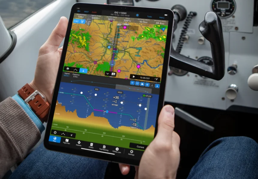
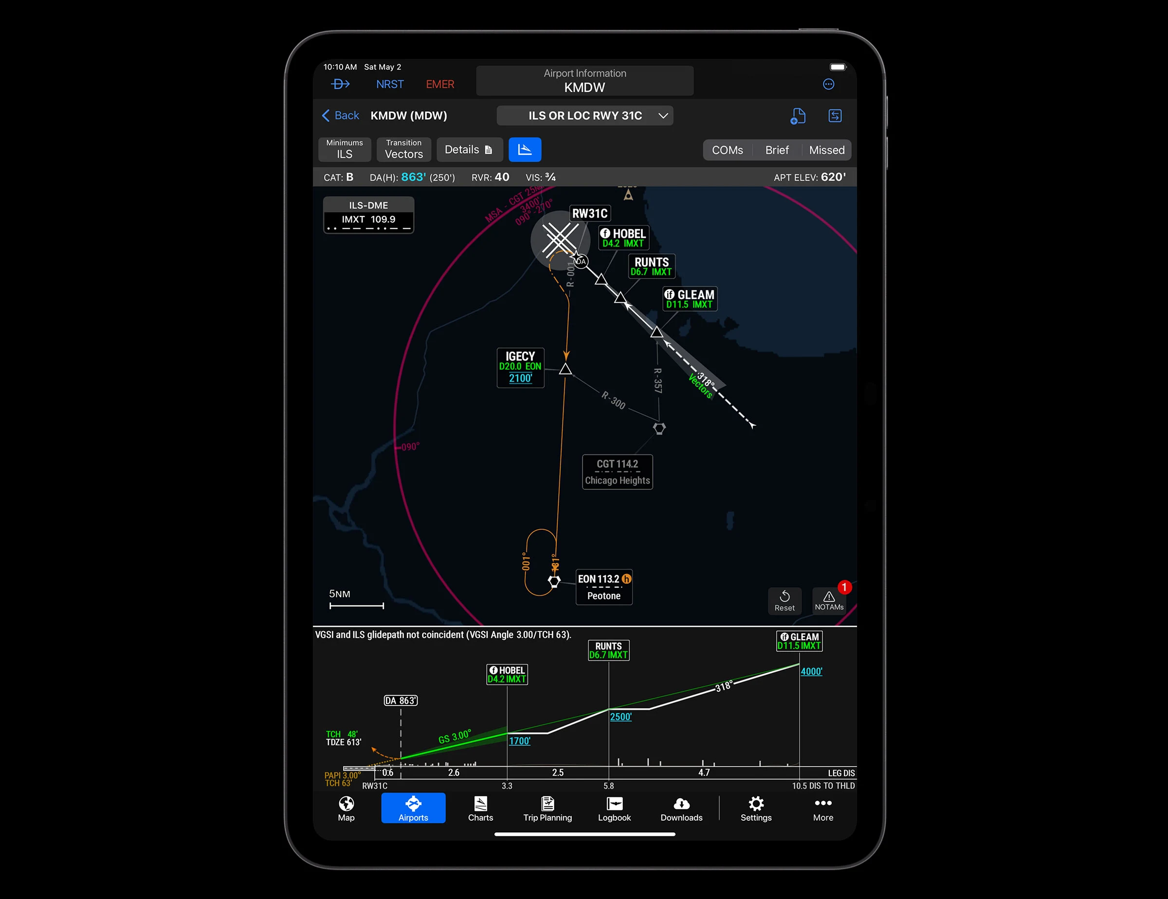
SmartCharts is a data-driven app that seeks to simplify aviation charting, with pilots able to create a chart that is specific to their flight. Selections can be made based on operations – including aircraft type, arrival approach, and runway type – that then produces a clear chart, without unneccessary information and clutter.

Developed over the last nine years, SmartCharts provides a long-awaited update to aviation charting alongside ensuring the interface is both intuitive and user-friendly. The app only presents relevant information and simplified charts, reducing potential errors and minimising distraction.

SmartCharts uses pre-collected and digital data from global sources that allows for consistent and adjustable charts. Pilots can zoom and pan within the chart, accessing a range of information such as instrument approach procedures (IAP), departure procedure (DP), standard terminal arrival (STAR), and realistic airport diagrams. This flexible feature allows details and notes to be easily seen and highlighted, reducing the risk of overlooked data.

The development of SmartCharts also aims to improve situational awareness, with pilots now having the ease of referencing weather, terrain and traffic on one simple platform. Extra detail is also viewable on SmartCharts – including airport lighting systems, hold short lines, windsock locations, communication frequencies, and alternate minimums data. Garmin has carefully designed these diagrams so that they are easily understood and pilots do not have to memorise airport symbols – however, the ability to switch between SmartCharts and the traditional FAA chart is offered.

Additionally, pilots no longer have to carry out mental maths with SmartCharts’ use of digitalised data and the availability of minima, allowing for automatic calculations to be made. This can further prevent human mistakes.

Phil Straub, Garmin’s Executive Vice President and Aviation Managing Director, has said:

“Terminal procedures have long been cluttered with outdated or superfluous information that may not be relevant to a pilot’s flight, obscuring important details that could be easily missed. Garmin SmartCharts allows all pilots to quickly and easily tailor procedures to highlight the most relevant and key information in a simplified, optimized format to ultimately help to enhance safety and situational awareness.”

Garmin SmartCharts, airport diagram © Garmin

How to Get SmartCharts

SmartCharts is available through Garmin Pilot which can be found at Garmin’s website or via their app. A Premium subscription must be purchased for SmartCharts access. Garmin offers a free trial period for thirty days and has recently reset this data for those who have used it in the past, allowing more users to experience SmartCharts.

SmartCharts currently covers the U.S. and the Bahamas. To use SmartCharts, a compatible device is required, needing either built-in GPS or a suitable GPS receiver. This provides the option of downloading SmartCharts on a mobile, tablet or laptop.

Will you be trying out SmartCharts? Let us know what you think about it.

You Might Also Like

Heathrow Airport to Trial Waitrose-Relay Collaboration
Fiji Airways: Vancouver Links Strengthen North American Network
Norse Atlantic Airways Approved for UK to Pakistan Flights
Air Charter Scotland Begins Scheduled Flights with Wick–Aberdeen PSO Route
US Airlines Gender Marker Rule Takes Effect for International Flights
Share This Article
Facebook Twitter Email Copy Link
What’s your thoughts?
Love0
Sad0
Happy0
Angry0
ByEllie Man
Aviation Reporter - With a passion for research and travel, Ellie is a Journalism Intern who aims to share engaging pieces to wide audiences, all the while presenting her own spirit and voice in her written work. Outside of Travel Radar, Ellie is an avid fan of F1 and NHL!
Previous Article Tourists walking at an airport to show international tourist arrival World tourism soars: International tourist arrivals up 5% in 2025
Next Article A Photo of a Departing FedEx Airplane FedEx and Neste Launch Sustainable Aviation Fuel Initiative
Leave a Comment

Leave a Reply Cancel reply

Your email address will not be published. Required fields are marked *


Stay Connected

FacebookLike
TwitterFollow
InstagramFollow
YoutubeSubscribe

Trending News

A woman celebrating and holding a blue and white flag, with trees in the background.
Uruguay blames FIFA for travel delays ahead of World Cup match
Airports Incidents & Accidents Travel
Side view of a Scandinavian Airlines (SAS) Airbus A320 in flight against a clear blue sky, captured on final approach with its landing gear fully extended. The white fuselage features “Scandinavian” written in large grey lettering along the side, with the blue “SAS” logo near the front. The engines beneath the wings are painted dark blue, and the tail is also dark blue with a white star‑shaped emblem. The aircraft’s wings are slightly flexed, with flaps deployed, and the nose is angled slightly downward as it descends.
SAS and Garuda Indonesia sign new codeshare agreement to boost Scandinavia–Indonesia connections
Airlines Aviation Route Development
A large pink, white and blue jetliner flying in a blue sky
Wizz Air reports drop in earnings amid Iran war
Airline Economics Airlines Aviation
A Boeing B-52 Stratofortress on runway before take off
US Air Force B-52 bomber crashes shortly after take-off from California base
Aircraft Breaking News Incidents & Accidents
Delta Air Lines Boeing 767-3P6/ER (reg. N1501P, cn 24983/334) taking off at Stuttgart Airport (STR/EDDS) taken on 7 February 2011, 11:06:32
Starlink vs. Amazon: Airlines race to upgrade in-flight Wi-Fi, as new ‘connectivity arms race’ takes shape
Airline Economics Aviation Technology

Travel Radar is the leading digital hub for all things aviation and air-travel. Discover our latest aviation news, aviation data, insight and analysis.


Discover

  • Latest News
  • Subscribe
  • Weekly Digest
  • Contact Us
  • Privacy Policy
  • About Us
  • Advertising
  • Media Coverage
  • Press & Events
  • Join Our Team
  • Our Brands

Signup to our Newsletter!

And get the latest aviation news via our weekly news digest!

© Travel Radar Media Ltd. 2015-2026 | ISSN #2635-0696 | Trademark #UK00003579704
adbanner
Welcome to the TR Community!

Sign in to your account

Not a member? Sign Up